BIEVR-LIO: Robust LiDAR-Inertial Odometry through Bump-Image-Enhanced Voxel Maps
用体素级“凹凸高度图”挖出隧道、平地等几何欠约束场景里的细微结构,撑住 LiDAR-Inertial 里程计的配准约束Mining subtle structure out of geometrically ill-constrained scenes such as tunnels and open flat ground with voxel-level "bump images", so as to sustain the registration constraints of LiDAR-Inertial odometry
Patrick Pfreundschuh, Turcan Tuna, Cedric Le Gentil, Roland Siegwart, Cesar Cadena, Helen Oleynikova · ETH Zürich(Autonomous Systems Lab / Robotic Systems Lab / Mobile Robotics Lab)Patrick Pfreundschuh, Turcan Tuna, Cedric Le Gentil, Roland Siegwart, Cesar Cadena, Helen Oleynikova · ETH Zürich (Autonomous Systems Lab / Robotic Systems Lab / Mobile Robotics Lab)
移动机器人越来越多地进入几何欠约束的环境(笔直隧道、大片平地),此时点云配准缺乏足够约束,LIO 精度下降甚至发散。BIEVR-LIO 提出一种体素级定向高度图(“bump image”)地图表示,直接编码平面之外的细微几何偏差,并配合地图感知的双分辨率点采样策略,把计算集中在真正有信息量的区域,在多传感器、多平台、多数据集上用同一组参数取得了鲁棒且高精度的里程计效果。Mobile robots increasingly operate in geometrically ill-constrained environments (straight tunnels, large flat areas), where point cloud registration lacks sufficient constraints and LIO accuracy degrades or even diverges. BIEVR-LIO proposes a voxel-level oriented height image ("bump image") map representation that directly encodes the subtle geometric deviations beyond a plane, and pairs it with a map-informed dual-resolution point sampling strategy that concentrates computation on genuinely informative regions, achieving robust and highly accurate odometry across multiple sensors, platforms and datasets with one and the same parameter set.
LIO 系统在几何信息稀疏的环境(直隧道、大片平坦地形)中鲁棒性明显下降,因为观测到的几何形状不足以约束点云配准。已有的应对思路各有短板:检测退化(degeneracy)的方法通常依赖额外传感器提供辅助里程计,增加了系统复杂度;仅用 LiDAR-惯性数据的近期方法只能处理短段退化;利用 LiDAR 强度信息作为额外线索的方法虽然效果不错,但依赖稠密扫描,与稀疏或不规则扫描模式的传感器不兼容。LIO systems lose robustness markedly in environments with sparse geometric information (straight tunnels, large flat terrain), because the observed geometry is not enough to constrain point cloud registration. Existing remedies each have drawbacks: methods that detect degeneracy usually rely on additional sensors to supply auxiliary odometry, which adds system complexity; recent methods that use only LiDAR-inertial data can handle only short degenerate stretches; methods that exploit LiDAR intensity as an extra cue work well but depend on dense scans and are incompatible with sensors that have sparse or irregular scan patterns.
“We observe environments often considered uninformative are rarely degenerate in a strict sense, as real-world scenes typically contain subtle geometric variations that render the problem well-constrained in principle.”
论文的核心洞察是:被认为“信息缺乏”的环境,严格意义上很少真正退化——真实场景通常存在细微的几何变化,只是现有 LIO 系统的地图表示分辨率不够,无法在实时约束下捕捉这些细粒度结构。为此作者提出 Bump-Image-Enhanced Voxel Representation(BIEVR):把每个体素内的局部表面几何显式编码为一张 2D 高度图(“bump image”),既保留细节,又能常数时间查表、支持高效的直接 scan-to-map 配准。The core insight of the paper is that environments regarded as "uninformative" are rarely degenerate in a strict sense — real-world scenes usually do contain subtle geometric variations; it is merely that the map representations of existing LIO systems lack the resolution to capture such fine-grained structure under real-time constraints. The authors therefore propose the Bump-Image-Enhanced Voxel Representation (BIEVR): the local surface geometry inside each voxel is explicitly encoded as a 2D height image ("bump image"), which preserves detail while still allowing constant-time lookup and supporting efficient direct scan-to-map registration.
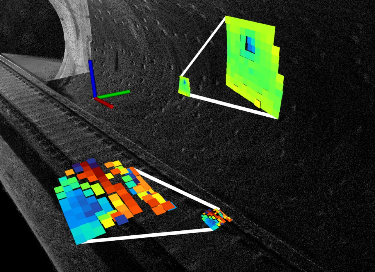
Figure 1:BIEVR-LIO 在隧道场景中通过与高分辨率 bump-image 增强体素地图配准,实现鲁棒里程计。彩色的 bump image 清晰展示了墙壁凹槽和轨道床的几何细节。Figure 1: BIEVR-LIO achieves robust odometry in a tunnel scene by registering against a high-resolution bump-image-enhanced voxel map. The colored bump images clearly display the geometric detail of the wall recesses and the track bed.
7/7GEODE 数据集全部序列不发散,多数基线在多条序列上发散(RE>20%)No divergence on any GEODE sequence, whereas most baselines diverge on several sequences (RE>20%)
0.053 mNewer College Cloister 序列上最低 ATE RMSE,取得 SOTALowest ATE RMSE on the Newer College Cloister sequence, reaching SOTA
2.7×ID 采样相比 HR 均匀高分辨率采样,配准点数从 13907 降到 5039(Shield1)Compared with HR uniform high-resolution sampling, ID sampling cuts registration points from 13907 to 5039 (Shield1)
1 组参数1 param set所有传感器 / 平台 / 数据集统一使用同一套参数,无需逐场景调参One and the same parameter set across all sensors / platforms / datasets, with no per-scene tuning
02 Method
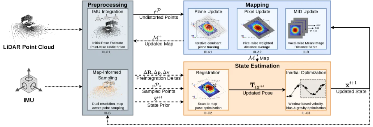
BIEVR-LIO 采用松耦合(loosely-coupled)设计:位姿完全由 scan-to-map 配准得到(不引入惯性残差),IMU 只用于点云去畸变和提供配准初值;配准后再优化速度、重力方向和 IMU 零偏。系统围绕两个核心组件展开:BIEVR 地图表示,以及地图感知的点采样策略。BIEVR-LIO adopts a loosely-coupled design: the pose comes entirely from scan-to-map registration (no inertial residual is introduced), and the IMU is used only to deskew the point cloud and to provide the initial guess for registration; velocity, gravity direction and IMU biases are optimized afterwards. The system is organized around two core components: the BIEVR map representation, and the map-informed point sampling strategy.
Figure 2:BIEVR-LIO 系统总览。线条表示状态更新前(⋯)、中(- - -)、后(—)的信息流:IMU 积分给出初始位姿与去畸变 → 地图感知采样 → 与 BIEVR 地图做 scan-to-map 配准 → 惯性量优化(速度/重力/零偏)→ 用全部点更新地图。Figure 2: Overview of the BIEVR-LIO system. The line styles denote the information flow before (⋯), during (- - -) and after (—) a state update: IMU integration provides the initial pose and deskewing → map-informed sampling → scan-to-map registration against the BIEVR map → optimization of the inertial quantities (velocity/gravity/bias) → map update with all points.
Bump-Image-Enhanced Voxel Representation
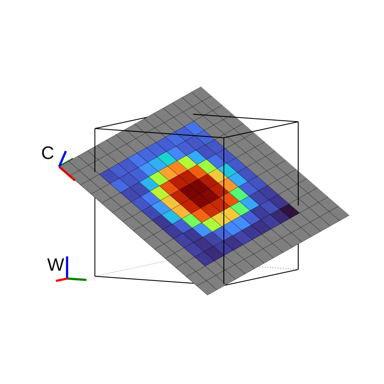
已有 LIO 系统常把表面近似为平面以获得高效的配准约束,但支持区域太大会抹平几何细节,太小又导致平面估计不稳定。BIEVR 不再假设一个平面能完全解释表面,而是显式记录每个体素相对其主平面(dominant plane)的局部偏差:该平面作为高度图的“像平面”,像素存储沿平面法向的细粒度偏差。每个体素在累积至少 4 个点后初始化,通过将体素 8 个角点投影到该平面确定图像所需的最小尺寸;投影到像素坐标后,像素值随点相对平面的高度不断更新。这样既保留了粗糙平面模型会丢失的细微几何线索,又避免了直接从点估计高分辨率 3D 基元带来的不稳定性。配准时直接在 bump image 上最小化输入点与体素高度图之间的高度残差,无需先计算中间几何基元(如法向、边缘等)。Existing LIO systems often approximate surfaces as planes in order to obtain efficient registration constraints, but too large a support region smooths away geometric detail, while too small a one makes the plane estimate unstable. BIEVR no longer assumes that a single plane can fully explain a surface; instead it explicitly records the local deviation of each voxel with respect to its dominant plane: that plane serves as the "image plane" of the height image, and the pixels store the fine-grained deviations along the plane normal. Each voxel is initialized once it has accumulated at least 4 points, and the minimum required image size is determined by projecting the 8 corners of the voxel onto that plane; after projection to pixel coordinates, the pixel values are continuously updated with the height of the points relative to the plane. This preserves the subtle geometric cues that a coarse plane model would lose, while avoiding the instability of estimating high-resolution 3D primitives directly from points. At registration time, the height residual between the input points and the voxel height image is minimized directly on the bump image, without first computing intermediate geometric primitives (normals, edges, etc.).
Figure 3(b):点被投影到像素坐标,像素值依据相对主平面的高度不断更新,形成体素的 bump image。Figure 3(b): Points are projected to pixel coordinates and the pixel values are continuously updated according to the height relative to the dominant plane, forming the bump image of the voxel.
Map-Informed Point Sampling
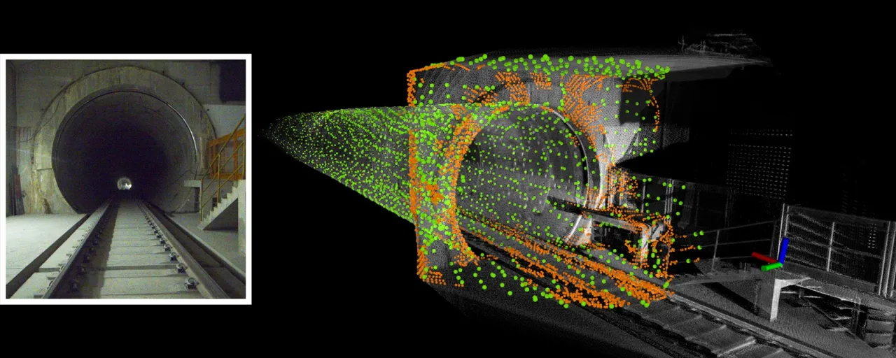
BIEVR 捕捉到的细粒度几何,只有在附近确实采样到输入点时才能为配准提供约束。但对输入扫描做统一高密度降采样会显著增加配准计算量,还会引入无信息区域的噪声。为此论文提出两阶段、地图感知的采样策略:先用高度图本身的非平面程度作为指示值——即 Mean Image Distance(MID,观测像素上高度值的均值),MID 越大说明该体素几何细节越丰富、越可能提供有信息量的配准雅可比。采样分两步:第一步用 IMU 初始位姿把去畸变点云变换到世界系,以 0.1 m 高分辨率降采样,并为落入 MID 最高的 300 个体素中的点全部保留;第二步对其余体素中的点做 0.5 m 粗分辨率降采样。高密度点集中在关键几何细节区(如隧道入口拐角、轨道床),低密度点覆盖其余区域,最终点集用于配准。The fine-grained geometry captured by BIEVR can constrain registration only when input points are indeed sampled nearby. Yet uniformly dense downsampling of the input scan markedly increases the registration cost and also introduces noise from uninformative regions. The paper therefore proposes a two-stage, map-informed sampling strategy: it first uses the non-planarity of the height image itself as an indicator — the Mean Image Distance (MID, the mean of the height values over the observed pixels); a larger MID means the voxel is richer in geometric detail and more likely to provide informative registration Jacobians. Sampling proceeds in two steps: the first step uses the IMU initial pose to transform the deskewed point cloud into the world frame, downsamples it at the high resolution of 0.1 m, and keeps all points that fall into the 300 voxels with the highest MID; the second step downsamples the points in the remaining voxels at the coarse resolution of 0.5 m. The dense points concentrate on regions of key geometric detail (tunnel entrance corners, the track bed), the sparse points cover the rest, and the resulting point set is used for registration.
Figure 4:Shield1 序列中的点采样。灰色为累积点地图;基于 Mean Image Distance,橙色(密集)点采样在隧道入口拐角、轨道床等显著区域,绿色(稀疏)点采样在天花板、地面等信息量较低的区域。Figure 4: Point sampling on the Shield1 sequence. Grey is the accumulated point map; guided by the Mean Image Distance, orange (dense) points are sampled in salient regions such as the tunnel entrance corners and the track bed, while green (sparse) points are sampled in less informative regions such as the ceiling and the ground.
03 Experiments
作者在 Newer College、ENWIDE、GEODE、MARS-LVIG、GrandTour 等多个公开数据集上评估,覆盖不同传感器(Ouster OS0-128、Livox Avia、Hesai XT32 等)、平台与环境。对比基线包括 KISS-ICP、GenZ-ICP、Traj-LO、FAST-LIO2、DLIO、iG-LIO、RESPLE、RKO-LIO,在高分辨率扫描数据集上还加入依赖强度信息的 COIN-LIO。评估指标为绝对轨迹误差 ATE RMSE(m)和 10 m 轨迹段上的相对误差 RE RMSE(%);相对误差超过 20% 视为失败(×),此时不再报告 ATE。所有实验统一使用 Table I 中的同一组参数,不做逐场景 / 逐数据集调参。全部实验在 Intel i7-11800H CPU 上完成。The authors evaluate on several public datasets including Newer College, ENWIDE, GEODE, MARS-LVIG and GrandTour, covering different sensors (Ouster OS0-128, Livox Avia, Hesai XT32, etc.), platforms and environments. The baselines compared against include KISS-ICP, GenZ-ICP, Traj-LO, FAST-LIO2, DLIO, iG-LIO, RESPLE and RKO-LIO, with the intensity-based COIN-LIO added on the high-resolution scan datasets. The metrics are the absolute trajectory error ATE RMSE (m) and the relative error RE RMSE (%) over 10 m trajectory segments; a relative error above 20% counts as failure (×), in which case ATE is no longer reported. All experiments use the same single parameter set of Table I, without per-scene or per-dataset tuning. All experiments were run on an Intel i7-11800H CPU.
Newer College(几何信息丰富场景) (geometry-rich scenes)
Method
Cloister ATE/RE
Stairs ATE/RE
QuadHard ATE/RE
FAST-LIO2
0.078 / 0.2%
× / 3497.2%
0.049 / 0.3%
COIN-LIO(用强度) (intensity)
0.078 / 0.3%
0.102 / 0.7%
0.046 / 0.3%
BIEVR-LIO
0.053 / 0.2%
0.056 / 0.6%
0.051 / 0.3%
BIEVR-LIO 在 Cloister 和 Stairs(狭窄楼梯,几何约束有限)上取得最低误差;在有剧烈旋转和突变运动的 QuadHard 上,松耦合设计配合 IMU 去畸变与配准先验也表现稳健。BIEVR-LIO attains the lowest error on Cloister and Stairs (narrow staircases with limited geometric constraints); on QuadHard, which involves aggressive rotations and abrupt motion, the loosely-coupled design together with IMU deskewing and the registration prior also behaves robustly.
在 GEODE 数据集的 Offroad4/5、Shield1/4/5、Tunneling1/2 共 7 条序列上,BIEVR-LIO 全部完成且在其中 5 条取得最优 ATE,而 GenZ-ICP、Traj-LO、FAST-LIO2、DLIO、iG-LIO、RESPLE、RKO-LIO 均在多条序列上发散(×)。ENWIDE 的 Tunnel 场景是论文明确指出 BIEVR-LIO 不如依赖强度信息的 COIN-LIO 的例外情况(见 Limitations)。On the 7 GEODE sequences Offroad4/5, Shield1/4/5 and Tunneling1/2, BIEVR-LIO completes all of them and obtains the best ATE on 5 of them, whereas GenZ-ICP, Traj-LO, FAST-LIO2, DLIO, iG-LIO, RESPLE and RKO-LIO all diverge (×) on several sequences. The ENWIDE Tunnel scene is the exception the paper explicitly points out, where BIEVR-LIO falls short of the intensity-based COIN-LIO (see Limitations).
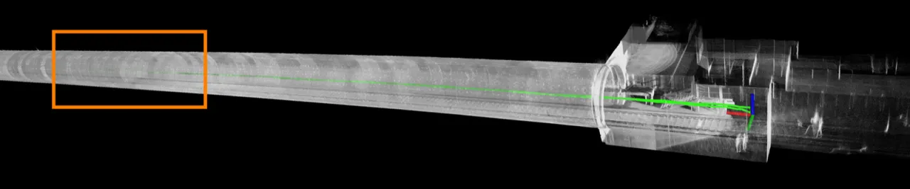
Figure 5(局部):Shield1 序列内部视角的累积点云地图,清晰呈现轨道床和隧道墙面凹槽;经过 700 m 轨迹后地图无明显漂移。Figure 5 (detail): Accumulated point cloud map from an interior viewpoint of the Shield1 sequence, clearly rendering the track bed and the recesses of the tunnel walls; after 700 m of trajectory the map shows no noticeable drift.
Ablations
论文在 Shield1 / FieldS / Cloister 三条序列上做消融(ATE RMSE,m):仅用平面地图(Plane)在 Shield1 上直接发散;换成 BIEVR 表示但不加解析雅可比项(∂I/∂ξ)同样在 Shield1 发散;加入雅可比项后 Shield1 收敛但误差较大(0.401);采样策略从随机降采样(RD, 0.604)换成本文的地图感知双分辨率采样(ID)后,Shield1 误差降到 0.256(最优)、FieldS 降到 0.159(最优)。运行时对比显示,ID 采样相比全局高分辨率采样(HR)在 Shield1 上把配准点数从 13907 降到 5039、单帧耗时从 15.7 ms 降到 12.8 ms,同时精度不降反升——验证了“把计算集中在有信息量的区域”这一设计的有效性。The paper ablates on the three sequences Shield1 / FieldS / Cloister (ATE RMSE, m): a plane-only map (Plane) diverges outright on Shield1; switching to the BIEVR representation but leaving out the analytic Jacobian term (∂I/∂ξ) likewise diverges on Shield1; adding the Jacobian term makes Shield1 converge, though with a fairly large error (0.401); after replacing random downsampling (RD, 0.604) with the paper's map-informed dual-resolution sampling (ID), the Shield1 error drops to 0.256 (best) and FieldS drops to 0.159 (best). The runtime comparison shows that, compared with global high-resolution sampling (HR), ID sampling cuts the number of registration points on Shield1 from 13907 to 5039 and the per-scan time from 15.7 ms to 12.8 ms, while accuracy improves rather than degrades — confirming the effectiveness of the design of "concentrating computation on informative regions".
04 Limitations
Note:以下四点均为论文 Section V “Limitations” 中作者原文陈述,非推测。Note: All four points below are the authors' own statements in Section V "Limitations" of the paper, not speculation.
需要足够点密度填充像素,且未做插值Needs sufficient point density to fill the pixels, and no interpolation is done
Bump image 的每个像素若没有点落入则无法使用(no infilling is applied and empty pixels cannot be used),这会降低系统在低分辨率 LiDAR 或高传感器速度下的表现;此外配准需要相对准确的初始位姿才能得到有意义的像素残差。作者指出这两个问题都可以用多尺度图像金字塔(multi-scale image pyramids)缓解。A pixel of the bump image cannot be used if no point falls into it (no infilling is applied and empty pixels cannot be used), which degrades the system with low-resolution LiDARs or at high sensor speeds; in addition, registration requires a reasonably accurate initial pose in order to yield meaningful pixel residuals. The authors note that both issues can be alleviated with multi-scale image pyramids.
未利用 LiDAR 强度信息,严格退化环境下不如 COIN-LIODoes not exploit LiDAR intensity, and is inferior to COIN-LIO in strictly degenerate environments
本方法不使用 LiDAR intensity,在几何本身不足以约束配准的严格退化环境中效果有限,例如 ENWIDE 数据集中的 Tunnel 场景;论文原话指出 COIN-LIO 这类基于强度的方法在这些情况下仍能可靠工作。The method does not use LiDAR intensity, so it is of limited effect in strictly degenerate environments where the geometry itself is insufficient to constrain registration, such as the Tunnel scene of the ENWIDE dataset; the paper states that intensity-based methods such as COIN-LIO still work reliably in those cases.
缓解退化但不显式检测退化Mitigates degeneracy but does not explicitly detect it
BIEVR-LIO 降低了退化带来的影响,但并不显式检测退化,作者认为可以自然地与现有的退化缓解策略结合使用。BIEVR-LIO reduces the impact of degeneracy but does not explicitly detect degeneracy; the authors argue that it can be naturally combined with existing degeneracy-mitigation strategies.
不检测或建模动态物体Does not detect or model dynamic objects
系统不处理动态物体,这会限制下游任务的效果,例如论文中展示的用于足式机器人落脚点规划的高程地图(elevation mapping)构建。The system does not handle dynamic objects, which limits the effectiveness of downstream tasks, such as the elevation mapping construction for legged-robot foothold planning demonstrated in the paper.